


Would you like to know the current traffic information and updates from the comfort of your home or while driving using your mobile device? Find out how congested or smooth traffic is anywhere in the city using EasyNav.
EasyNav will help you navigate easily to avoid traffic congestion, stress and running late.
The main purpose of this app (EasyNav) is to provide real-time traffic information for users to help them in planning their movement, make informed decision and navigate through different routes easily.The application provides two different modes in which traffic information could be gathered and made available to other users.
The first mode is the Pedestrian (Manual) mode which allows users (Non drivers) of the app to post traffic updates to the Traffic Information Management System (TIMS) manually, the application detects the user's current location, provide users with options to select the current traffic situation of the location before it’s been sent, once the report is posted successfully, it is made available to other users who are currently within the district and this could help them to plan their movement better based on the current traffic situations.
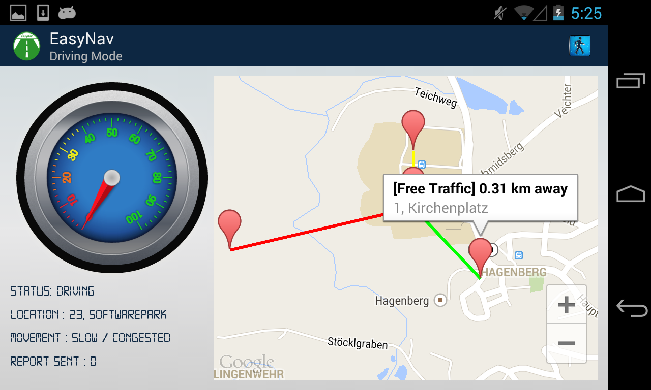
The second mode is the Driving mode or automated reporting mode, under this mode,the driver is presented with a map displaying the most recent traffic updates around his location that is available on the Traffic Information Management System.Also the application is paired with OpenXC to retrieve data from the vehicle sensors such as the location co-ordinates, the vehicle speed amongst others. All these data are sent automatically (without the driver's interaction)to ensure the safety of the driver at certain intervals to the Traffic Information System where it’s been processed and made accessible to other drivers and commuters. For example, if the average speed of all the vehicles at a particular road is less than 10km/h, the system may interpret this as "Traffic congestion", between 10 and 40km/h is categorized as "Partial Movement" while values greater than 40Km/h are categorized as "Free Traffic".
This approach would really help in solving traffic congestion, and would be more efficient if the app could be distributed to people who are always driving around and plying different routes such as Bus/Taxi drivers for efficient data gathering. Also, certain authorities such as the Police could also use the app in driving mode as they are always on patrol in different areas of the city. The only thing required from them is just to activate the driving mode and the reports are being sent and received automatically.
EasyNav provides three major types of Traffic Status which are represented with three different colors that are well known to the road transport users (Green, Yellow, Red) Each of the colors signifies the current traffic situation of a location at a particular time. These colors have the similar meaning with the regular traffic signals on the roads (Free Traffic,Partial Movement,Congested). The colors are used to provide information to users in the manner in which they are familiar with to enhance the app usability .
In a broader context, these traffic reports may also be projected on some LCD displays, billboards in some certain locations to make the information available to road users (drivers) in real-time.For example, it may be a display that shows up between the period while you are stopped by the red traffic light and waiting for the green light to be on.
This solution would really make a great impact in taming and reducing traffic in highly congested areas in London.

Log in or sign up for Devpost to join the conversation.