
What is Landmark?
Landmark is a mobile application for walking directions with step-by-step photos of geotagged landmarks. It is a unique way of navigation without replicating paper maps and compasses. We leverage open source mapping technologies, image repositories, community-engagement tools, and our own algorithms to make city navigation visual, intuitive and safer by tailoring navigation to pedestrian needs. Most navigation applications are rooted in maps and driving, not landmarks and walking. A significant percentage of people prefer navigating visually and based on landmarks. Our goal is to be the best walking application, as societal trends show that people are driving less, owning fewer cars, and moving to more “walkable” cities.
How your submitted solution’s features and functionality helps to reduce collisions between vehicles and pedestrians (including cyclists) in urban street environments.):
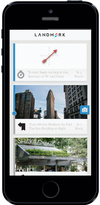
*Fewer distractions from typically complex directions. Our simple user interface is specifically designed for pedestrians which means app frustration and increased awareness of your surroundings. Walking navigation should provide an experience that is unique from driving navigation. Instead of “Turn right in 0.7 miles”, we use “Turn right in 4 blocks”. Instead of “Head Northwest on Connecticut”, we say “Turn left”. These small changes in details can help pedestrians focus more on their route over deciphering their next step.
*Better habits. We encourage better habits of looking up at the buildings and your surroundings instead of looking down at your phone on busy streets. We want to build the ultimate walking app with beautiful photos and a strong crowdsourcing community who are passionate about their city and the architecture around them.
*Pedestrian-friendly & safe routes. As urban population grows, high speed roadways have become ubiquitous to ease heavy traffic. This also means pedestrians are more vulnerable to vehicle accidents. Landmark navigation is pedestrian focused. It guides users through pedestrian friendly, well-lit side sidewalks and avoid dangerous roadways.
*Walking with confidence. Landmark encourages pedestrians to stay on sidewalks and cross at crosswalks. With clear concise directions at every turn and visual feedback at every corner, people can walk with confidence even in unfamiliar neighborhoods. Users can share sidewalk conditions, road closures and safety tips with the landmark community.
Why now?
- Trends + The time is now. 30 years of academic research suggests that some people navigate better using maps and compasses and other navigate more effectively using visual landmarks. The data tends to skew by gender which might be a reason why the tech industry hasn’t thought of this quite yet. .This app was not possible until today. Smartphones now have cameras, geotagging capabilities and tons of mapping data, all in our pockets and the places we travel to.
- Growing market. The market size for walking navigation is growing as urban population increases with 19 of 51 largest US metropolitan areas reporting that center cities grow faster than their suburbs between 2012 and 2013 (CityLab). Thirty largest metropolitan areas are home to 46% of total US population. People are driving less, owning fewer cars, and moving to more “walkable” cities (Foot Traffic Ahead Study).
- Landmark-centric navigation is worldwide. Among travelers, urbanites, commuters and everyone in between, the market for those seeking intuitive directions spans worldwide. In places like India, Tokyo and Lebanon, there are no street signs-- only Landmarks. As trends indicate that more people will own smartphones and prefer urban areas, Landmark is equipped to grow.


Log in or sign up for Devpost to join the conversation.