Devpost
Devpost for Teams
Grow your developer ecosystem and promote your platform.
Drive innovation, collaboration, and retention within your organization.
Sort by:
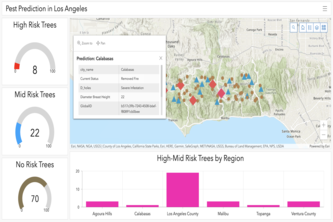
GIS platform in predicting infestations.
"The ability to simplfy means to eliminate the unnecessary so that the necessary may speak" Our website is simple, easy to use and adresses all the requirements set out by PIANGO
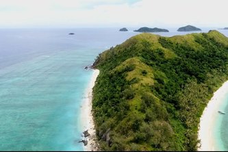
Our robot turtle is designed to detect, monitor, and quantify marine debris with the use of ML algorithms, real-time high precision object detection programs and an eco-friendly look in the ocean.
A Ceasar lover group did this for Cypher VII - Exploring W&M statues with Puzzles!
Protection of Soil erosion and shallow landslips by adopting eco-friendly and economical bio-reinforcement techniques. Efficacy of solution is evaluated by DEM using geospatial techniques
Herman, Poseidon's last hope, a robot turle going to save the ocean like a superhero. Herman is designed to detect, monitor, and quantify marine debris with the use of machine learning algorithms.
5gmjh5g
This project aims to increase COVID-19 transparency among students at UNC Chapel Hill.
Our project combines DataCuse's information on road quality, and Google Cloud Platform's Map API, to determine the grade of roads along your commute. Take care of yourself, and your car!
Our game let players try to survive in random risks through actions. Along with the real incidents it allows users to feel the fear Asian Americans experience everyday because of the hate around them.
Skylar is an online educational platform where students in developing countries can learn in real time and gain relevant work skills and have access to global job opportunities.
Tackling urban job inaccessibility through policy.
Dongo policing is a mobile VR experience for the police and security department to employ analytic methods of policing new cities
sometimes you succeed and sometimes you don't :o
Have you ever been flummoxed by parking in Pittsburgh? Our app CarPark can help!
By leveraging Synthetic Aperture Radar, Hyperspectral, and Weather data, we are solving a physics and sensor fusion problem to predict where and when wildfires will ignite.
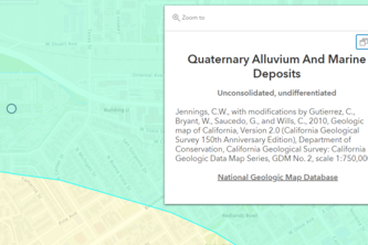
Are you curious to know what type of rocks or faults are just below you? This simple Javascript application can do that! It can also be used for other underground infrastructure in the future!
Using the deep learning capabilities in ArcGIS Pro and the ArcGIS Python API, we developed a tool that will automatically create LRS event features given street level imagery of street signs.
We enhance community engagement by connecting nonprofits with donors based on location and need. Local people helping local organizations to improve their shared community.
To aid land managers in quickly identifying and responding to tree disease and mortality, we developed a computer vision model to ID diseased and dead trees from open-source available Landsat data.
Flood Watch uses the National Water Model to predict flood extents and immediately notify users if their house is at risk of flooding.
Bring your designs to the community
Find local events and and activities in San Diego, based on who you're with and how you feel.
Analyze agricultural field sustainability practices