Devpost
Devpost for Teams
Grow your developer ecosystem and promote your platform.
Drive innovation, collaboration, and retention within your organization.
Sort by:
Our team developed a dashboard that visualizes the survival of trees over time. The dashboard has been developed using ArcGIS JavaScript API, and it will help to improve tree management practices.
Human trafficking prevention tool power by artificial intelligence.
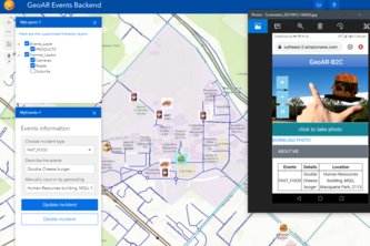
Due to the pandemic, many small businesses have been impacted. I hope my GeoAR B2C Solution can bring changes to businesses and consumers, help economy recovery - where there is change, there is hope.
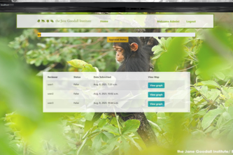
DocuMap is an interactive Web App for the Jane Goodall Institute to streamline their conservation science and mapping lifecycle to support faster agreements and decision-making process using DocuSign.
Proof of concept and some use case
Review and Approval of Eastern Chimpanzee Range maps involving embedding of ArcGIS maps in Docusign envelopes ,using the Docusign Developers API, and Decision makers Sign-off.
A web app built to help streamline the Jane Goodall Institute's conservation and mapping process.
a web application that helps to manage maps created on ArcGIS, this web app uses DocuSign and ArcGIS apis. each map study is considered as a list of map versions. (incremental versions).
Our website serves as a one stop solution for decision-makers across the globe to collaboratively develop and review the dynamic conservation maps in simple steps.
An application (iOS version) for Jane Goodall Institute to create, edit, collaborate, review and sign their conservation maps for the Eastern Chimpanzee
An android application, easy to access conservation maps where you can edit, manage and share maps easily and allow review and approve iterations of maps to finalize the map.
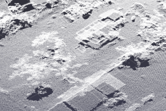
The project proposes an approach for the development of classifiers for LiDAR point cloud, based on methodologies and tools that have been studied.
Saving the Earth through information and collaboration
Creating a seamless process for the Jane Goodall Institute to faster review, change, update and approve dynamic conservation maps in collaboration with stakeholders all over the world.
Tacare made EZ
Document signature app.
City farms are great, but where to start? Planners waste time and money searching for sites. But now there's Truss - a site suitability app that locates vacant city parcels for potential urban farms.
VaxFinder helps people locate vaccination clinics quickly and effectively. Users are able to simply text a phone number, then we respond with the best possible location and route.
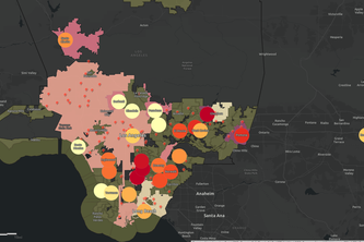
California: home to Esri, but also home to some of the worst air quality in the country. Our Android app empowers users to see what others can't through realtime data and visualizations of pollutants.
Using AQI, Asthma, and Hospital location data, we are able to identify high risk areas for air pollution related illnesses.
A web-based participatory mapping software enabling collaborative conservation planning for the Eastern Chimpanzee Range.
HeatVIS is an ArcGIS web application that uses temperature and demographic data layers to visualize the disproportionate effects of urban heat islands on underprivileged communities in Los Angeles.
Using GIS and Software Development to improve access to bike transit in Washington DC
The Reward to Explore! With a GeoBlockchain enabled Trails and Routes App, those who enjoy hiking now have an opportunity to earn rewards towards their next outdoor adventure.